
Unpacking Islamabad
A new study of the master plan for Islamabad, Pakistan, using space syntax analysis

The following is an excerpt of an academic article I wrote with Myrto Exacoustou, presented at the 2024 Space Syntax Conference in Nicosia, Cyprus. Read the full article on academia.edu.
On May 23, 1960, the evening before the Greek consulting planning firm Doxiadis Associates presented its plan to the Pakistani authorities for the design of their country’s new capital of Islamabad, Constantinos Doxiadis proposed a footrace.
The visionary architect and city planner was keen on reviving ancient Greek traditions, and the night before the presentation, Doxiadis held a small running competition with his staff of architects, planners, and engineers in the courtyard of Flashman’s Hotel in Rawalpindi.
To his colleagues, it was no surprise that Doxiadis was the victor.
The next day’s presentation was hailed as a success. In front of President Ayub Khan and officials across the Pakistani government, Doxiadis spoke for three hours about his 20-year plan for Islamabad, as well as the immediate 5-year goals of construction. The lecture was followed by a jeep tour of the Margalla Hills, the building site in question. By the end of the day, Khan—who had seized power in Pakistan through a military coup two years before—had agreed in principle to Doxiadis’ master plan.
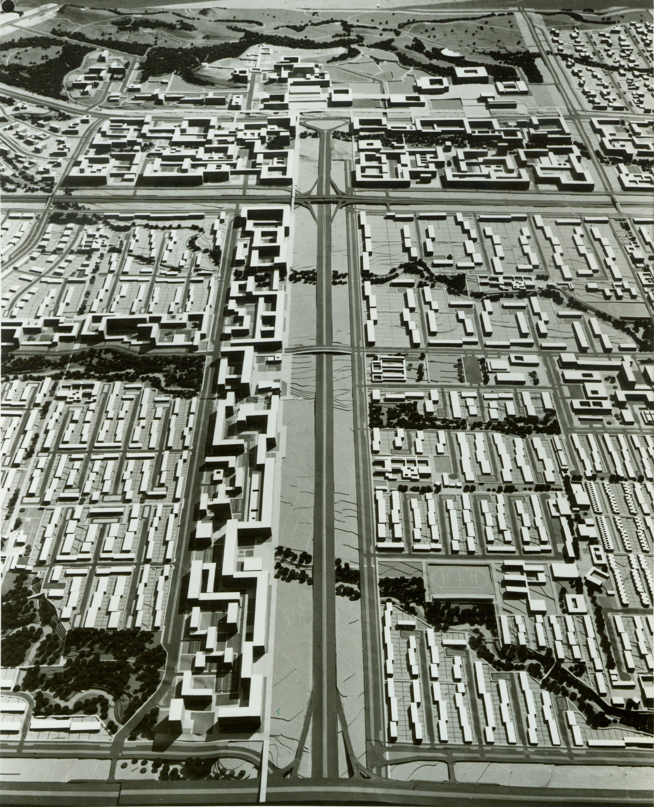
So it was decided. Doxiadis Associates, a major planning consulting firm based in Athens, Greece, would supervise the construction of the new Pakistani capital. Their project, like Lúcio Costa’s capital of Brasilia that had come before, was an experiment in tabula rasa planning, but Islamabad would be unique in that would be pursued under Doxiadis’ trademark design philosophy of “ekistics, the science of human settlements.” Doxiadis’ ekistics was an interdisciplinary approach to urban design, but one that still featured many design precepts of modernism.
As Abbasi wrote, “functional zoning and total design are the fundamental conceptions of the 20th century modern urbanism, particularly when it is concerned with master-planning the new capitals”; ekistics as implemented in Islamabad was no exception. However, Islamabad’s novelty went further, crafted from a more specific ekistical framework. Doxiadis had also developed the concept of a “dynapolis,” a city built on a gridiron system so as to dynamically grow along an axial line. Islamabad, built on a grid to expand from the nearby city of Rawalpindi, would be a test of the dynapolis concept.
The stakes were clear. In Islamabad, Doxiadis’ ekistics and dynapolis would be put to the ultimate test— could they form the framework of a fully-functioning, inorganically growing city? Members of the Doxiadis team, who worked from 1959 to 1963 to create the layout of this city (as well as several complementary and overlapping projects that included aspects of the initial implementation of the plan, understood that the full results would not be evident for another two generations.
As it happened, the joy and confidence that Doxiadis enjoyed in the footrace and the ensuing presentation was not shared by all of his collaborators. After the city plan for Islamabad was formally approved by the Pakistani Federal Capital Committee (FCC) in October 1960, Orestes Yakas, one of the principal designers of the plan, examined the model of Islamabad with mixed feelings. General Yahya Khan, chairman of the FCC (and a future president himself), took note. “Why are you melancholic?” Khan asked, adding, “This is a day of joy for all of us.” Yakas replied, “this is the first time in my life, that I see the model of an important work, in which I participated, that I shall not be alive to see in reality, after forty or fifty years.”
More than sixty years have passed since the construction of Islamabad. The city has reached a stage of maturity that Yakas only dreamed of—an iteration that now allows us to assess the successes and shortcomings of Doxiadis Associates Master Plan. With the analytical tools of space syntax, we can finally evaluate Islamabad’s design using axial analysis.
Doxiadis in Pakistan
Doxiadis earned international acclaim as a planner during the Marshall Plan period in Greece, when he served as a governmental liaison between the American authorities of the European Recovery Program in Greece and the reconstruction authority in Athens.
In 1959, Doxiadis was assigned the project of designing the new capital; the plan was approved in November 1960. Construction began in October 1961 under the supervision of Pakistan’s Capital Development Authority (CDA), the successor to the FCC; in Pakistan, Doxiadis Associates consulted on many different facets of implementation. By 1963, however, Doxiadis Associates’ involvement in Islamabad waned as American funding of the projects through the International Cooperation Administration and Ford Foundation concluded. The city was essentially “completed” in 1966.
In the initial years since Islamabad’s foundation, locals and international experts alike saw the Doxiadis plan as an extremely thorough document which made considerations for nearly all aspects of life. “The scheme is looked upon with pride by many of the people who referred to it,” wrote British architect Janet Pott
during a 1963 visit to the city.
By the 21st century, the plan has been criticized for its suburban character, its failure at facilitating adequate transportation, and the inadvertent creation of what now amount to informal settlements housing 50,000 in the city’s Class V superblocks. Reflecting on modern Islamabad, Robert Allen Mohr cited a local proverb: “Islamabad is a short drive from Pakistan.” Indian researcher Maneesha Tikekar has gone so far as to call Islamabad “a beautiful city without soul.”
With the use of the space syntax axial analysis, we aim to reconstruct and analyze the experience and possibilities of movement flows, to study the accessibility and integration of the street and pedestrian system, and to determine the relative circulation of these networks, as designed by Doxiadis Associates for the core of the city. These include sectors G6 and F6, two superblocks of Class V (2.2 km by 2.2 km); the administration, governmental, and diplomatic enclaves; and finally, the commercial zone named the “blue area.” By juxtaposing the space syntax axial analysis with an evaluation of the planners’ intents, we aim to uncover new insights into the effectiveness of the plan in practice.